
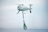
GeoDragon sensor system integrated with T-20 UAV


A sensor system that can create 2D and 3D images in near real time has been flown on the T-20 Tier II unmanned aerial vehicle (UAV) for the first time. The sensor, called the GeoDragon system, has been developed by Urban Robotics, and will be released in mid-2014.
The GeoDragon system can create 3-D reconstructions in near-real time and output high-resolution digital elevation models, LIDAR-like datasets, and wide area maps. The system is enclosed in a wing-mounted pod, and will bring significant mapping capabilities to the T-20 UAV.
GeoDragon imagery is post-processed using automated 3-D algorithms to rapidly generate large mapping and modelling datasets.
The T-20, built by Arcturus UAV, is a runway independent, Tier II class, small tactical UAV with a technical readiness level (TRL) 9. The primary mission of the Arcturus UAV is intelligence, surveillance and reconnaissance. Typical missions include aerial mapping, drug interdiction, fire-fighting, border patrol, force protection, search and rescue, as well as military ISR.
The T-20 can also carry EO/IR payloads simultaneously with the GeoDragon. An onboard GPS autopilot with waypoint navigation accepts multiple flight plans from the Ground Control Station, allowing the T-20 to return to a specified location autonomously after up to 16 hours of flight. The UAV is powered by a 190cc an air-cooled, four-stroke, fuel injected engine; and the carbon fibre composite construction used in the T-20 airframe allows for payloads up to 65 lbs.


More from Uncrewed Vehicles
-
![Jammer resistant drone designs spark search for countermeasures]()
Jammer resistant drone designs spark search for countermeasures
The Russia-Ukraine conflict has driven another stage of evolution for drones and the counter measures to defend against them.
-
![L3Harris launches Amorphous software for control of uncrewed platforms]()
L3Harris launches Amorphous software for control of uncrewed platforms
The new Amorphous software is a universal controller that would allow a single operator to control a swarm of “thousands” of uncrewed systems, from drones to underwater platforms.
-
![ideaForge unveils new UAVs at Aero India 2025]()
ideaForge unveils new UAVs at Aero India 2025
India UAV supplier ideaForge has launched the Netra 5 and Switch V2 drones at Aero India 2025, boasting of enhanced endurance, AI-driven autonomy and improved operational capabilities.
-
![Shaping the future of defence: What 2025 holds for the global drone market]()
Shaping the future of defence: What 2025 holds for the global drone market
The UAV market is experiencing unprecedented growth, with innovations in technology and battlefield applications driving demand across military sectors. From the battlefields of Ukraine to NATO exercises and beyond, drones are transforming how wars are fought and supported.
-
![Maris-Tech confirms customers signing up for Jupiter Drones codec and AI-powered system]()
Maris-Tech confirms customers signing up for Jupiter Drones codec and AI-powered system
Launched at AUSA in October, the company’s multi-stream video codec is attempting to bring a new lease of life to drone technology through its AI accelerator.
-
![AUSA 2024: Quantum-Systems targets big 2025 with UAS developments]()
AUSA 2024: Quantum-Systems targets big 2025 with UAS developments
Quantum-Systems has been upgrading its UAS family, with new versions of the Vector, Reliant and Twister drones set for release throughout 2025.


